Carpe Diem Fine Books, ABAA

Lt. George Horatio Derby
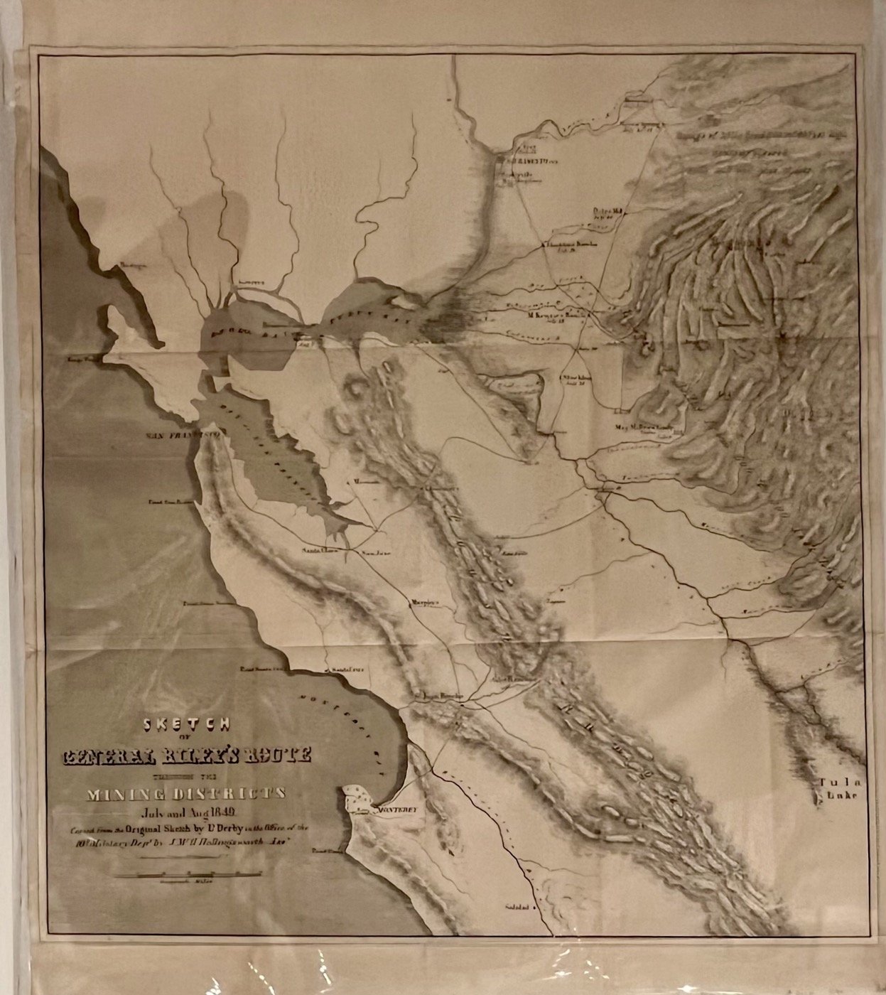
Sketch of General Riley's Route through the Mining Districts July and Aug. 1849
$350
Item Details
[Washington, D.C.], [U.S. Congress]
Lithographed map (21x19½"), plus margins. Fold lines, as issued. Light general wear; a very good map.
This map, created by U.S. Army Topographical Engineer Lt. George Horatio Derby, documents the reconnaissance tour of Brig. Gen. Bennet Riley, the last Military Governor of California, through the early Gold Rush mining regions of Northern California. Produced from Derby's original field sketches in the office of the 10th Military Department, it was published as an appendix to Riley's official report dated September 20, 1849, and included in U.S. Senate and House documents in 1850. The map traces Riley's daily route (marked with dates from July 10 to August 20, 1849) from Monterey northward via San Francisco, across the Central Valley, and into the mining districts along rivers like the American, Cosumnes, Mokelumne, Calaveras, Stanislaus, Tuolumne, Merced, and Mariposa. A cornerstone of Gold Rush cartography, providing the first printed names and locations of central Sierra foothill diggings—essential for prospectors and historians. (Wheat, Maps of the Gold Region #79)
Carpe Diem Fine Books, ABAA
Mary Hill & James Bryant
245 Pearl Street
Monterey, CA, 93940
United States
Phone: 831-224-2272
Cell: 831-224-2272 (text)
Featured Catalogue
Visit Website
Specialities
Signed, California, Americana
More Information
Booth 7
Shipping and Returns
Your satisfaction is guaranteed. All items are offered subject to prior sale and are returnable (notification of return must be made within ten days and returns made promptly). Postage is additional. We accept most forms of payment including check or bank draft, most credit cards and PayPal. We are pleased to work with Institutional requirements. 9.25% sales tax will be charged California residents.
Open Times
We are a physical shop open by appointment/chance in historic Monterey, California.Additional Information
Carpe Diem Fine Books offers a discriminating selection of out-of-print, and out of the ordinary books in all fields - with a special emphasis on the history and literature of California and the West.